All-day Car-free Hike: East Bay National Skyline Recreational Trail
Hiking time: 11-13 hours
Maps:
Transit schedule: BART
Start point: El Cerrito del Norte BART station
End point: Castro Valley BART station
Notes:
- The most important thing to know about this hike is that it is very, very long. Although there are a few steep sections, overall the hike is moderately hard elevation-wise. But you really need to decide before going if you have the endurance to be out walking for 11-13 hours.
- Because this hike takes a long time, summer is best due to the long daylight hours and (usually) mild weather. If you go in the winter, you will need to bring a headlamp for the end of the hike.
- East Bay parks close at 10 pm. Start this hike as early as you can. I took the first BART train on a Saturday, which got me to El Cerrito del Norte at about 6:30 am. BART starts running later on Sundays, so that is a less ideal day.
- This would not be a good hike to do immediately after a period of rainfall. Some of these trails, especially those on cattle-grazing land, get extremely muddy and unpleasant. This hike is challenging enough without also having to navigate mucky trails.
- Bring lots of food with you. Food is only reliably available at the end of the hike on the way down Redwood Road to the BART station. Right before you exit Chabot, there is a golf course with a restaurant (limited weekend hours) and a bar.
- There are a few places to refill water along the way, but bring plenty of water with you.
- If you would like very detailed descriptions of natural features along these trails, you may want to look at the book East Bay Trails (David Weintraub). For navigation, however, I would recommend using the East Bay Parks maps (available as PDFs online, or in print at several places along the route), which indicate the Skyline Trail with a triangle symbol.
- If you have Google Maps on your phone, use it as a reference as needed for checking your location. Most of the trails are visible with Bicycling selected. And as an aside: if you have a phone that supports it, please do get (and know how to use) Google Maps. I helped two groups of people on this trip who were lost, all of whom had smartphones which would have helped them find their way again very quickly.
Directions:
- Exit El Cerrito del Norte BART station, and walk north on the Ohlone Greenway path.
- After passing through the Wildflower Area, turn right onto Conlon Ave.
- Cross Key Blvd and make the next left onto Mono Ave.
- 2nd Right onto Poinsett Ave.
- Left and then right towards Rosalind.
- Left on Hillside Ave., then and immediate right on Yuba St.
- After several blocks, turn right at McBryde Ave.
- Entering Wildcat Canyon at the Alvarado picnic area to the official start of the Skyline Trail, you have two choices: turn right immediately and walk through the very long parking area, or go straight into the picnic area and follow the trails to the right to eventually connect back to the parking area. The second option is more interesting but a little confusing (some misleading signs).
- At the end of the parking area walk straight onto the Wildcat Creek Trail.
- Left at the Belgum Trail to climb up to the ridge. Here and throughout Wildcat Canyon you will pass unmarked human- and cattle-made trails.
- Right at the San Pablo Ridge Trail.
- Merge onto the Nimitz Trail, a paved multiuse path.
- Continue on Nimitz Way into Tilden Park.
- At Inspiration Point, take the Curran Trail to your right just past the restroom and before the gate to parking and the road.
- Very shortly turn left, following signs for the Seaview Trail.
- Cross the road, and continue following the Seaview trail as it heads up to the ridge again.
- Follow the Seaview Trail the rest of the way through Tilden Park.
- Just past Vollmer Peak you reach the Steam Trains parking area. Refill water here.
- Continue carefully along the entrance road (busy here on weekends) and the straight on the trail through EBMUD land.
- Carefully cross Fish Ranch Road to continue on the Skyline Trail.
- Continue on the Skyline Trail as you enter Sibley Volcanic Preserve.
- Continue on the Skyline trail through the preserve. The Sibley Staging Area is another good place to refill water.
- Continue following the Skyline Trail into and through Huckleberry Botanic Preserve. Some steep downhill sections here. You will pass some markers along the way for a self-guided nature trail.
- Carefully cross Pinehurst Road and continue on the Skyline Trail to Redwood Regional Park.
- Right at the trail intersection towards Skyline Gate.
- At the next intersection, follow signs to the West Ridge Trail.
- Follow West Ridge for a long ways, almost all the way through Redwood Regional Park.
- Right at the Golden Spike Trail (single-track, sign was hidden by plants on my visit), then stay right at fork.
- Left at MacDonald Trail to MacDonald Gate Staging Area.
- Continue on the MacDonald Trail into Chabot Regional Park.
- Approaching the Bort Meadow Staging Area, follow signs for the Skyline Trail and Brandon Trail.
- Follow the Brandon Trail the rest of the way through Chabot to Willow Park Golf Course. Depending on the time, you may be able to get food here. There is also a bar at the golf course.
- Continue past the golf course on the trail alongside the Redwood Road until you reach Proctor Staging Area and leave the park.
- Continue down Redwood Road through a residential area, then a commercial strip (many places to get food here), and finally to Castro Valley BART station.
Get Outside and Take a Car-Free Hike This Summer
Any time of year is a good time to take a car-free hike, but summer — with additional traffic to outdoor destinations — is an especially great time to ditch the car in favor of taking transit to parks, trails, and beaches. Following is a quick index to car-free hikes by region of the Bay Area:
San Francisco
Southwest San Francisco Nature: Lake Merced, Fort Funston, and More
San Francisco Waterfront: Ferry Building to Fort Point
Mission to Haight Hike: Corona Heights, Buena Vista Park, Golden Gate Park Oak Woodland
Western San Francisco Hike: Presidio, Lands End, and Sutro Baths
San Francisco’s China Basin and Potrero Hill
East Bay
Circling the Lafayette Reservoir
Carquinez Strait Regional Shoreline: A Trip Along the California Riding & Hiking Trail
Bayside Berkeley: A Stroll Around the Berkeley Marina and Cesar Chavez Park
North Bay
Secret Sausalito Stairways to the Marin Headlands
Tiburon Tour: Ring Mountain and the Tiburon Peninsula
Headlands for the Holidays (and Sundays): Rodeo Beach to Tennessee Beach
Larkspur Loop: King Mountain, Dawn Falls Trail, Paths and Stairways
Bayside Marin: Las Gallinas Wildlife Ponds and McInnis County Park
Peninsula and South Bay
Sweeney Ridge and Milagra Ridge Along the Bay Area Ridge Trail
Rancho San Antonio Trails to Black Mountain Peak
Pacifica Coastal Hike: Mori Point and Beaches, Three Ways
Edgewood County Park From Cañada College
Car-free Outdoors is taking a break, but hopefully with the above hikes you will have plenty of options and ideas for car-free hikes in the meantime!
Maps for Car-Free Hikes, Part 2 – Online Maps
This is the second in a two-part series on maps for planning car-free outdoor adventures. The first article discussed print maps good for planning walks that connect trails, parks, and open space with transit. Print maps are usually a starting place for me, a way to get ideas for possible routes. Once I have planned out a potential route, I sometimes just try the hike without doing much other research. However, online maps can be very helpful in answering questions about a route that cannot easily be answered by looking at the print versions.
There are many fancy map-related applications online that could be useful for trip planning, but I tend to find Google Maps to be sufficient for my needs. For most trips, entering the route on Google Maps allows you to quickly figure out the distance of a hike — much easier than trying to measure in on the print map and add up a bunch of numbers. I tend to underestimate the length of a route, so mapping the route online helps me get a better idea of the actual distance and make adjustments if necessary. I have found that drawing lines using Google’s MyMaps feature is more useful than entering starting and end points in Google Maps. Keep in mind, however, that although Google Maps directions does depict some trails you may be better off using the mileage from your print map to get an accurate estimate of distance of some trails on your route — particularly when the route has lots of switchbacks. Also, in some cases it is helpful to draw multiple lines in MyMaps for different sections of the route, rather than one line for the entire route.
Although online maps are useful as a time saver for route planning, the best use I’ve found for them is avoidance of potentially dangerous routes. Anyone who has been on foot or on a bicycle on a route with no shoulder/sidewalk or near a busy freeway interchange will know the value of being familiar with the route ahead of time. For routes near freeways, busy thoroughfares, or rural roads, I like to use the satellite view of Google Maps. I check for sidewalks, for crosswalk locations, and for other features of the roads that might affect my route. Often it is very easy in satellite view to see how to avoid a problem by walking on one side of the street, moving the route a block in one direction, etc. Occasionally, if I can’t get enough information in satellite view, I will use the Google Maps Street View feature. It’s not available for every location, obviously, but in most urban areas I have been able to check on the location of a bus stop or see details of a street where the overhead view was blocked by trees. Street View can also sometimes be useful for finding the exact location of a trailhead, path, or stairway.
Despite careful planning, you may sometimes find discrepancies while out on the route. If you or one of your hiking partners has a smartphone, you could also pull up a map on the phone and use the phone’s GPS features to find an alternative route or check the directions. I am definitely not suggesting you need to purchase an expensive phone, however; much of the time I reference the directions I have typed up/written out ahead of time and occasionally refer to a printed map. In fact, having now described the utility of online maps in general I would like to also discourage you from using online maps and technology too much for your hikes. It can be tempting to use all of the cool online mapping tools out there to see your exact route before ahead of time or to check your location multiple times along the route. But I prefer to leave some mystery and surprise to the journey — otherwise it’s not much of an adventure!
Once I have completed a hike and am satisfied with the route, I enter the detailed route in MyMaps for future reference. MyMaps has options for either keeping your maps private or for making them public, and it is an easy tool to learn and use. If you want to get a better idea of the how the maps look, you can look at the maps that I’ve included for each of the hikes on this blog, or browse the collection of Car-Free Outdoors maps.
Planning out a car-free outdoor adventure does take some time, but it is a lot of fun if you are a map-lover. If you don’t find this enjoyable or don’t have the time for it, there are plenty of routes here on Car-Free Outdoors to follow — and more on the way!
Maps for Car-free Hikes, Part 1: Print Maps
Print and online maps are key to planning to car-free outdoor adventures, so I thought I’d take some time to share some of my favorites for those you wanting to plan your own hikes. I use both print maps and online mapping to plan out hikes; in the second part of this article I will talk about the online maps. Eventually, I’ll also write about bike maps.
When I first attempted to plan hikes from transit, I realized that I would need more than park maps. Park maps are, of course, great for planning any hike. Most of the official park maps from Bay Area agencies have accurate distances and are freely available either at park entrances or from the park office. And, most can be downloaded online and printed on standard 8 1/2 x 11 paper. I won’t list them all here, as the individual hike descriptions include links to specific park maps. However, when you want to connect between parks and from street to trail, it is much easier to visualize a route using map with larger coverage.
As with anything else, you could easily spend a bunch of money on maps. If you want to start planning your own longer hikes, I recommend starting with the maps in the region where you live or where you plan to do much of your hiking. I find that in most cases shopping for maps in a physical store is more useful than ordering them online, especially in cases where you want to compare maps from the same region from different mapmakers. REI carries a wide selection of maps in its stores around the Bay Area, as do many of the independent outdoor gear stores.
San Francisco
San Francisco Bike Map & Walking Guide (Rufus Graphics): In addition to its usefulness as a bike map, this one is great for planning walking routes because it depicts the steepness of streets with shading.
Map & Guide to Golden Gate Park (San Francisco Recreation & Parks, Rufus Graphics): There are many online maps showing the locations of well-known spots in Golden Gate Park, but none show all of the park’s many paths in as great of detail as this print map.
North Bay
Southern Marin Trail Map (Tom Harrison Maps): This map shows the Marin Headlands and connections with Mt. Tam, the Bay Trail from the Golden Gate Bridge north through Sausalito, and the Tiburon Peninsula. Additionally, it shows the trails on Angel Island. Because of its scale, the trails in Fort Baker are not shown in great detail, so you will want to use the official park map when planning hikes in that area.
Trails of Northeast Marin County (Pease Press): This is an excellent map for planning Bayside hikes in Marin and in preserves near Highway 101 from San Rafael north to Novato. For easier planning of hikes from transit, I have marked the locations on my map of the Golden Gate Transit bus pads (which are at 101 exits).
Rambler’s Guide to the Trails of Mt. Tamalpais and the Marin Headlands (Olmsted & Bros.): This is my favorite of the choices for Mt. Tam maps. In addition to Mt. Tam and Muir Woods, the map shows Marin Municipal Water District land to the north and all of the Marin Headlands.
East Bay
Rambler’s Guide to the Trails of the East Bay Hills (Olmsted & Bros.): The Northern and Central East Bay Hills maps are some of my favorites despite the fact that they are older. They show the trails of the East Bay Regional Park District, the city and county parks, and the EBMUD lands, making it easy to plan routes that connect trails in different jurisdictions.
Map of Berkeley’s Pathways (Berkeley Path Wanderers Association): This map clearly depicts Berkeley’s pedestrian paths and stairways, of which there are over 130 for this small city! The map is clear and easy to read, and shows the connections with Tilden Park, the UC trails, and Claremont Canyon Preserve. Additionally, the Bay Trail connections with bordering cities are shown on the map.
Walk Oakland Map & Guide (Rufus Graphics): This is a very useful map for planning neighborhood routes to connect transit with trails in the Oakland hills. It shows neighborhoods, points of interest, street steepness, and BART and major transit centers. The map also shows Oakland’s many walking paths — though I wish the path markings were a bit more prominent and easier to see on the map.
Peninsula
Trails of the Coastside & Northern Peninsula (Pease Press): This map starts with the south end of San Francisco and shows parks and trails down the coast past Half Moon Bay. It actually shows transit routes, but because the map is older many of the routes have either changed or no longer exist. Nonetheless, a great map.
Trail Map of Central San Francisco Peninsula Trails (Wilderness Press): On this map you can see the trails from San Mateo south to Stanford University. This is an invaluable map for planning longer hikes on the mid-Peninsula particularly because it shows the Crystal Springs Trail, which runs north to south and allows connections between parks.
Trail Map of the Southern Peninsula (Trail Center): This is a nice map of the many parks along the ridge from Portola Valley south to Saratoga Gap and Rancho San Antonio and Fremont Older preserves. You can see the trails in relation to Foothill College, which is the nearest public transit access point for much of this area.
Pathways Map, Los Altos Hills: This very detailed map shows the many pathways in Los Altos Hills, which connect with Rancho San Antonio and several smaller preserves and open spaces. Although it covers a fairly small geographic region, it is a great map to have for Peninsula hikes. Many different hikes can be constructed by planning different routes using the paths, which are not represented in detail on any other map that I have seen.
For all regions: If you have one already, the Thomas Bros. maps are actually fairly useful for planning car-free adventures, despite the fact that they are designed for drivers. I use them mostly when trying to figure out the best route through a neighborhood to connect to a trail. The Thomas Brothers. maps will have more street detail than any of the larger hiking maps and sometimes are more accurate than online maps for smaller streets. These maps are fairly expensive, though, and generally too bulky/heavy to bring along for the hike, so again I recommend starting with the map for the region where you will be spending the most time doing hikes.
Angel Island Perimeter Hike
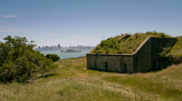
View of San Francisco from Battery Drew — by Joe Reifer
This hike circles the perimeter of Angel Island State Park, visiting many historical and natural points of interest, including the Angel Island Immigration Station, abandoned forts and batteries, and coves and beaches. Despite being a popular tourist destination, the trails and paths on Angel Island are usually not overcrowded, as many visitors spend their time on the island picnicking near the ferry cove or taking the tram tours. On clear days, you will have amazing views of San Francisco from the island.
Places visited: Angel Island State Park
Approximate length: 6 miles (see notes for variations)
Hiking time: 4-6 hours
Map: Angel Island
Terrain: Mostly flat with a couple of moderate hills; paved and dirt trails
Transit schedule: Angel Island Tiburon Ferry, Blue & Gold Fleet Angel Island Ferry
Start and end point: Ayala Cove Ferry Dock, Angel Island
Getting to the start point:
From San Francisco, take the Blue & Gold Fleet Angel Island Ferry from Pier 41 and the Embarcadero to Angel Island. You can take the Muni F-Market to Pier 41 or (my preference) walk from Embarcadero BART/Muni north on the Embarcadero to Pier 41.
From the Peninsula and South Bay, take Caltrain to Millbrae station. Transfer to BART, and take the San Francisco/East Bay train to Embarcadero station. From here, take the Muni F-Market to Pier 41 or (my preference) walk from Embarcadero BART/Muni north on the Embarcadero to Pier 41. Take the Blue & Gold Fleet Angel Island Ferry from Pier 41 and the Embarcadero to Angel Island.
From the East Bay, take BART to Embarcadero station. From here, take the Muni F-Market to Pier 41 or (my preference) walk from Embarcadero BART/Muni north on the Embarcadero to Pier 41. Take the Blue & Gold Fleet Angel Island Ferry from Pier 41 and the Embarcadero to Angel Island.
From the North Bay, take Golden Gate Transit 19 to the Tiburon Ferry Terminal. (Major transfer points for the 19 are Marin City, Strawberry Village, and the Seminary Drive Bus Pad.) Take the Angel Island Tiburon Ferry to Angel Island.
Notes:
- Note that you will be taking the Angel Island Tiburon Ferry if you are traveling from Marin, and the Blue & Gold Fleet Angel Island Ferry if you are traveling from all other destinations. The Angel Island Tiburon Ferry operates more frequently, but it is inconvenient for car-free travelers coming from destinations other than Marin. If you are coming from San Francisco, it is possible take the Golden Gate Transit 10 or 70/80 and transfer at Marin City to the 19 to get to Angel Island Tiburon Ferry. If you are taking the Angel Island Tiburon Ferry, note that cash and checks only (no credit cards) are accepted; make sure to check the current fares ahead of time and bring enough cash.
- This route is designed for those who want to avoid crowded trails, by taking the steep stairs to the perimeter road and doing a clockwise loop around the island. Taking the first ferry in the morning is also a great way to avoid the crowds and will allow you to explore the island without feeling rushed to make it back for the last ferry. The Angel Island ferries run on a more limited schedule from November through April; May-October will give you more options for your length of stay on the island.
- You can vary this route in a few places by taking alternate trails or roads. From the Immigration Station, the East Bay View Trail connects with Fort McDowell; it could be muddy in the winter or after heavy rains. A steeper hike is the loop to Mt. Livermore at the center of the island. Although it would be possible to do this hike in combination with the perimeter loop, I recommend doing these as separate hikes so that you have plenty of time to explore along the way and stop to enjoy the views.
- This route includes many great locations for lunch with a view. I recommend bringing a bag lunch, but you can also eat at the snack bar near the ferry.
Other Resources for Car-Free Outdoor Adventures
I’ve been meaning for some time to post some other resources beyond my own website, for those interested in getting outdoors without a car. However, this month’s issue of Sunset magazine was what finally inspired this post. In the March 2010 issue of this magazine with a circulation is 800,000 in Western states, is an article about planning a day trip in Union City that starts and ends at Union City BART! This looks like a fun trip for families, with a 20 mile bike route on the Alameda Creek Regional Trail, butterflies and flowers, and many good eating options along the route. Please write to Sunset and let them know you would like to see more car-free outings like this one!
A friend forwarded a website to me that documents a walk around San Francisco Bay (and to Bay Area summits) in increments over three years. As I started looking through site to get some ideas for future walks, I realized that this person had done many of his walks using public transit! If you are interested in doing some walking around the Bay, this site has some good notes about which routes are good and which are not so ideal for pedestrians, transit routes he used, and other valuable tips.
Several of the trips posted here at Car-Free Outdoors include good bird watching opportunities. If you would like more car-free birding opportunities and a chance to get out in a group setting, the Golden Gate Audubon Society often has birding-by-bike trips in its selection of outings, many of which conveniently start at transit stops. Check the calendar for upcoming trips.
 Many of the car-free hikes I have posted so far do not start directly at a trailhead, but instead use paths and neighborhood routes to show how you can connect transit to trailhead. A number of trailheads in the Bay Area are actually quite near transit, however, allowing you to take a hike with a minimum of time off the trail. The Transit & Trails website allows you to plan your trip to those trailheads using public transit. Find the trailhead you would like to visit, and get transit directions using 511 or Google Maps. I recommend checking the directions given for both 511 and Google Maps, as I’ve found that it really varies which one of the two will give you the best directions. Transit & Trails saves a ton of time and headache trying to find an address near the trailhead you wish to visit, which you would need in order to use 511 or Google Maps. Additionally, Transit & Trails includes campgrounds near transit stops! There are plans for community and sharing features in the future; register at the site to get email updates.
 If you live in or have plans to visit British Columbia, check out Car-Free BC. The websites and print book include and variety of outdoor trips accessible without a car, for hiking, backpacking, bicycle touring, kayaking, river rafting, birding, and other outdoor activities. It’s an amazingly exhaustive book that includes over 90 trips, along with maps, photos, and illustrations.
Know of any other resources for car-free outdoor trips? Post a comment or send me a note if you do.
Bayside Marin: Las Gallinas Wildlife Ponds and McInnis County Park
This bayside Marin hike is a nice option for winter, with plenty of birds and little mud, and also a great summer outing when the temperatures rise at inland parks. A variety of land uses can be observed on this tour, which passes wildlife ponds, sanitary district facilities, remnants of a Nike missile site, an old Air Force base, hunting blinds, an air strip, a skate park, golf course, and other recreational facilities.
Places visited: Las Gallinas Valley Sanitary District Wildlife Ponds, McInnis County Park
Approximate Length: 9.5 miles
Hiking time: 5 hours
Map: None online; see Google Map below
Terrain: Mostly flat with a couple of easy climbs, dirt and gravel paths
Transit schedule: Golden Gate Transit 70/80
Start and end point: Lucas Valley Bus Pad
Getting to the start point:
- From San Francisco, take Golden Gate Transit Route 70 or 80 bus from Mission Street and 1st Street (stop is right in front of the Walgreens on Mission). You can also pick up Route 70/80 at different points along its route along Mission, up Van Ness, and west on Lombard to the Golden Gate Bridge. Check the current San Francisco System map to see if there is a stop closer to you. Take the Route 70/80 to the Lucas Valley Bus Pad.
- From the Peninsula and South Bay, take Caltrain to the final San Francisco stop. Walk on 3rd Street towards Market, turn right on Mission, to the Golden Gate Transit stop at Mission and 1st. Or, from BART, take a San Francisco BART train to Montgomery Street station. Exit the station, walk Market Street towards the water/ferry building, turn right on 1st Street, and walk one block to the corner of Mission and 1st. Take the Golden Gate Transit Route 70 or 80 bus from here (stop is right in front of the Walgreens on Mission) to the Lucas Valley Bus Pad.
- From the East Bay, take a San Francisco BART train to Embarcadero station. Walk on Market Street away from the water/ferry building to 1st Street, turn left on 1st Street and walk one block to the corner of Mission and 1st. Take the Golden Gate Transit Route 70 or 80 bus from here (stop is right in front of the Walgreens on Mission) to the Lucas Valley Bus Pad.
- From the North Bay: Take Golden Gate Transit Route 70, 71 or 80 from any of the stops along its route. If you are coming from Petaluma/Cotati/Rohnert Park/Santa Rosa, you will be taking Route 80. From locations in Novato, San Rafael, and Marin City, you can take any of the three buses. Get off at the Lucas Valley Bus Pad.
Notes:
- This trip includes a full tour of Las Gallinas and McInnis Park. If you enjoy bird watching, you a may want to return and try different routes around the ponds. If you end up spending a lot of time at the ponds, you may with to skip the loop through McInnis Park. To do this after exiting McInnis across the stone bridge, just reverse the beginning of the directions and head back the way you came instead of turning in at the Bay Trail.
- This hike can be done year-round, with winter being especially good for bird watching. There is one short section at the start of the Bay Trail around McInnis that can be muddy after heavy rains. However, the rest of the route is on graveled and/or raised levee paths that stay relatively dry.
- This is a good hike for a picnic lunch; there are plenty of benches and picnic tables at different points in this route. There are a couple of restaurants on Smith Ranch Road, but otherwise not too many food options along the route.
- Getting to the southbound Lucas Valley Bus Pad is a bit confusing due to poor signage. Be sure to read the end of the directions for this route so that you do not make any dangerous crossing of freeway on-ramps.



Recent Comments